
OSLO FJORD
From the Swedish border to Larvik
Fjord with islands and capital city
The Oslo Fjord (Oslofjorden), which starts just north of the border with Sweden, is both the 70-mile approach to Norways capital city, and a rich cruising ground in its own right. Groups and islands offer scope for intricate rock-dodging and a wide choice of anchorages on either side of the outer fjord, and on the W side of the head of the fjord. Oslo, sprawled across the NE corner of the inner fjord, has a fine waterfront overlooking a maze of islands. The summer evenings are long and light, there is no need to worry about tide, and the rocks hold the heat of the sun. The water has been known to be over 20°C well into September, and its surprisingly clear and clean, given the amount of traffic and lack of tide.
Holding tanks are the norm for local yachts, and may well become compulsory in the area. In winter many of the bays and inlets are better suited to ice skating. Boats are either laid up ashore, or are protected by air bubblers which prevent the water from freezing. The main shipping channels are usually kept open.
Tide and current
There is so little tide in the Oslo Fjord that it can be ignored. Currents are more affected by local weather and topography than tide. The general flow to the outer fjord is anticlockwise: N along the Swedish coast, W across the mouth of the Oslo Fjord, and SW down the Norwegian coast. In calm weather, the prevailing flow is outgoing, but strong S wind results in a strong N-going current, particularly in the narrow section of Drøbak. Uncomfortable seas and a W-going current of 1-1.5 knots can occur off the SE end of Tjøme, the Sandefjord and Larvik fjords and across the mouth of Langesund. In the wider S reaches, a choppy sea builds up quickly. S winds and low pressure in the Skagerrak and the Oslo Fjord can also result in higher levels of water.
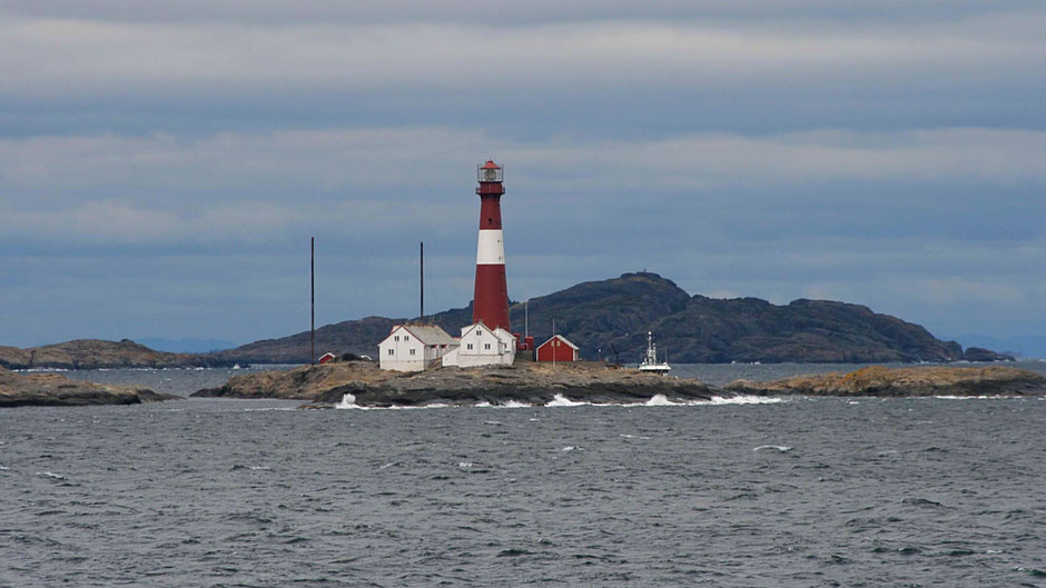
Approach and navigation
Entry to the Oslo Fjord from the Skagerrak, the sea between Denmark, Sweden and Norway, is guarded on either side by prominent lighthouses: Torbjørnskjær to the east and Færder to the west. It can be approached from Sweden, from Denmark across the Skagerrak, or as a continuation of a S coast cruise. Navigation in the fjord presents no difficulties, but this is a busy seaway and yachts should respect the need of commercial shipping, especially in the Drøbak narrows and the Oslo area.
The main fjord is well marked and will lit, but in mid-summer lights are barely needed. In the S section, there is plenty of scope for intricate daytime rock- and island-hopping on either side. The channels through the islands are well marked.
The route taken here is anticlockwise from the Swedish border, up to Oslo then down to Larvik. It is equally possible to cross and re-cross the Oslo Fjord.
SOUTHERN LIMITS OF OSLO FJORD
E: Torbjørnskjær lighthouse 58°59´.7N 10°46´.9E
W: Færder lighthouse 59°01´.5N 10°31´.5E
BUOYAGE
Towards Oslo and Swedish boarder (click here - page 27)
CHARTS AND MAPS (NORWEGIAN) NOTE: Datum varies!
Main and coastal series 1-5, Båtsport series A, B, C
Harbour series: 401, 402, 452, 472, 481, 482, 464, 465, 470, 486
Coastal chart series 201
Coastal atlas KystAltlas 1 (Strømstad-Lista)
Land maps Cappelens kart 50, Østlandet sør (1:150.000)
Harbour plans Den Norske los Vol. 2a
UK Admiralty Charts are also available
TIDAL RANGE AND CURRENT
Tidal range negligible (ca. 30cm), Tidal stream significant at Svelvik narrows in Drammensfjord. Standard Port: Oslo. Current anticlockwise from Swedish border in outer fjord, affected by wind, especially S, up to 3kns in Drøbak narrows.
EXPOSED OR DANGEROUS AREAS
Færder-Tvistein, Skagerrak W
APPROX DISTANCES FROM OSLO BY SHORTEST ROUTE
Halden 69M, Fredrikstad 56M, Hankø 46M, Moss 30M, Son 25M, Drøbak 16M, Horten 47M, Tønsberg 48M, Sandefjord 65M, Stavern 67M, Larvik 69M
FORECASTS
VHF forecasts Via Tjøme radio, Ch 16, see VHF chart for times and local channels, English forecast by request Ch 16 or Tel 120 (see plan for local numbers)
Navtex area L (Rogaland)
Coastal Waters forecast areas Inner Oslofjord (Oslo closed waters-Tofte), Outer Oslofjord (Swedish border-Tofte-Stavern), Stavern-Øksøy light
TRANSPORT
International and internal flights
Oslo (Gardermoen) to Oslo city 50km, fast and stopping trains (NSB, Flytoget), express bus,
Sandefjord Torp to Oslo ca. 110km, airport bus and train
Moss Rygge to Oslo ca. 66km, airport, bus and train
International ferries
Stena Line: Oslo to Fredrikshaven
DFDS: Oslo to Copenhagen
Color Line: Oslo from Hirthals and Kiel, Frederikshavn to Larvik, Strömstad to Sandefjord
DFDS: Copenhagen and Helsingborg to Oslo
Local ferries
From Oslo centre to Bydøy, islands in inner fjord, Drøbak to Oscarsborg, Horten to Moss
Road, rail and bus
Good services from both sides of fjord to/via Oslo.
Oslo city T-bane (underground), Trikk (tram), Buss (bus)